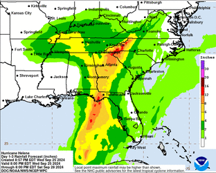
Hurricane Helene / Invest 97L

1727325079576.gif
Holy shit look at that rain in Appalachia there. 1-2 feet of rain expected. Definitely a bad time to hit up 4210 Wolfetown Rd, Cherokee, NC 28719.
I'm cautiously hype for Atlanta. There is a chance this bitch plows into the coast at full speed on a direct course for that shit hole. With how big it's wind field is, there a good probably the entire metro area comes under sustained hurricane force winds. Guarantee they are not prepared for that level of region wide impact.
Every year or so they get hit with squall lines that have tropical storm-force winds. Plus actual tropical storms every few years. It'll just knock down some trees and a bunch of branches and fuck up the shingles on your roof. Although I'm sure in the real shitholes like South Fulton (place where the mayor got arrested for burglary) they don't do much maintenance so there will be power lines and telephone poles and street signs flying everywhere.
 
I'm an unapologetic hurricane autist. Been watching them for years. This one is giving off the bad juju. It reminds me alot like Katrina. Katrina entered the central gulf as a category 1 let's not forget and it went ashore as a Cat 3.

Helene is very similar in wind field size, but it's speed means it will hit during its intensification period. Katrina was slow so while it hit Cat 5 on approach it's eye wall collapsed prior to land fall. It still brought hell with it in storm surge which was recorded as high as 28 feet.

So helene is not there yet, but at 20 feet it's already pushing pretty close and the forecast is still early. I would take this one seriously.

*edit*

It's important to remember that part of what allows front line States like Florida to quickly rebound from Hurricane strikes is other States being able to send help in the form of electric utility support and wat not. Helene is setting up to carve an absolute wrecking ball from the Florida Panhandle up to Ohio. States North of Florida may find themselves swamped with their own domestic issues. Meaning even if you just lose power, you won't have power for weeks.

It took Lousiana over a month to get the lights back on from Katrina.
Taking every hurricane seriously is pretty much the only way you ever get to a level of readiness that makes them manageable, so I agree. Obviously when I say "manageable," I'm thinking in terms of single-digit death tolls and no catastrophic aftermath. It's still an extreme natural event that isn't asking your permission for space in the calendar. A big part of my casual attitude about hurricanes comes from the fact that I'm not really vulnerable to flooding and the risk of damage from fallen trees or windblown debris is about as low as it can get. Being outside of the bughives and away from the waterfront gives me some sense of security that I otherwise wouldn't have.

Hurricane Danny is my own personal example of why you really shouldn't ever assume "no danger" from a given storm. By all normal metrics, it was about as close to a nothingburger hurricane as you can get. It barely reached minimum hurricane strength before landfall. Peak intensity was somewhere around 80mph sustained winds and 984mb minimum central pressure, with maybe a 6-foot storm surge. What made Danny dangerous was rain. It teabagged the Mobile Bay area for two or three days, essentially sitting in one spot and dumping almost 40 inches of rain in the area around the bay before it started moving again. Lower Alabama has a lot of areas with clay soil that drains very poorly, and even housing lots on high ground were flooding because of saturated soil and insufficient drainage.
 
Holy shit look at that rain in Appalachia there.
I was watching a weatherman talking about this, and he said this sort of flooding happens once every 2,000 or so years. It's much worse as well due to it being mountainous, the water will funnel into the valley and say 20" of rain can turn into 40" of rain because of it. If the models are correct, that area is going to get bad and people will likely die.

If anybody reading this is in a flood prone area, do not retreat into attics, you will become trapped and rescuers will not see you. Try to get onto a roof. Or get out of the area for the time being. Other than that, good luck.
 
What it currently looks like from space:
20242701436_GOES16-ABI-gm-GEOCOLOR-2000x2000.jpg
photo
G16_sector_gm_GEOCOLOR_24fr_20240926-1048.gif
gif
You can view animated photos from space here (warning .gov website, for the paranoid)
Tornadoes forming from bands of the hurricane are possible today, already have tornado watches out with many warnings already (at the time of writing, two)
day1otlk.gifday1probotlk_torn.gif

THERE IS AN ENHANCED RISK OF SEVERE THUNDERSTORMS FOR COASTAL AREAS OF NORTHEAST FLORIDA…GEORGIA…AND SOUTH CAROLINA​

### SUMMARY

Several tornadoes are expected today into tonight across the coastal Southeast in association with Hurricane Helene. The greatest threat is expected across parts of Florida into southeast Georgia, the Midlands and Low Country of South Carolina, and southern North Carolina.

Florida/Georgia and the Carolinas​

Hurricane Helene, centered 300-350 miles southwest of Tampa early this morning, will continue to move north-northeast and accelerate over the eastern/northeastern Gulf of Mexico today into tonight, with landfall expected in the Florida Big Bend region this evening. Consult National Hurricane Center forecasts and advisories for more track, intensity, and impact details.

Related to Helene's large size and increasingly fast forward speed, an associated increase of low-level flow/shear will occur across the Florida Peninsula today, southeast Georgia and parts of South Carolina by afternoon, and eventually into parts of North Carolina tonight. Low-level shear (and moisture/buoyancy) is already supportive of a tornado risk in some areas regionally, reference 12z observed soundings from Miami and especially Tampa Bay. However, this tornado-supportive scenario will diurnally increase and expand north-northeastward regionally through the afternoon and evening. Low-level hodographs will become quite large, with 0-1 km SRH increasing into at least the 250-500 m2/s2 range. This will support tornado potential with any low-topped supercells that are able to develop and persist within Helene's rain bands. Some tornado potential will reach into parts of North Carolina later tonight.
Stay safe, any floridaman kiwis out there.
 
What made Danny dangerous was rain.
This is what happened when Irma hit past the inital breaking point. It was severely weakened on landfall, but it stayed for a long time over all of Florida. It just kept raining, and when it moved, it kept raining still. It rained on and off for two weeks straight, and when a hurricane already filles the lakes and gutters, any extra rain will royally fuck shit up. You can't restore poeer when everywhere is water for days on end. That's the big bitch question I have: how much rain will happen in my area? We'll find out.
 
Holy shit look at that rain in Appalachia there. 1-2 feet of rain expected. Definitely a bad time to hit up 4210 Wolfetown Rd, Cherokee, NC 28719.
That must be a mountainous region where 1-2 feet are expected, I wouldn't be surprised if there are even higher amounts locally. Terrain induced precipitation (Orographic precipitation) is responsible for pretty much every absolute rainfall record, fortunately it is strongly correlated to grade so the areas where these enormous rainfall amounts are generally sparsely populated and they distribute water away from them incredibly fast.

The most well known example of this is perhaps Mount Waialeale in Hawaii where they average more than 30 feet of rain a year but it is hyper localized.

However the most extreme example of this is in the French overseas territory of La Reunion where multiple weather stations have observed upwards of 10 feet of rain from a single storm on multiple occasions, the record being 217 inches of rain from a single tropical storm in 2007.
 
It seems all but guaranteed that Helene is gunning right for the big bend of Florida, and there's an extra danger here that I don't think we've discussed in the thread: sinkholes. The big bend coastal areas are in the highest risk category for sinkhole formation, because so much of the below-ground rock is carbonate (stuff like limestone and dolomite). These are the kinds of rocks that water loves to do work on, and Helene is about to aggressively hurl a shit ton of water at them. As the saying goes, bad times friend ahead.
 
If anybody wants to watch a livestream with a weatherman, here's a good one, he has cameras up along the coast and is covering the tornadoes right now. He works with storm chasers so there probably be live footage when it really ramps up and makes landfall. He said it's going to be a category 3 but could possibly be a cat 4.

Parts of the mountains previously discussed could get more than 20" of rain. The last time a significant flood happened there was in 1916 resulting in 80 deaths. The projected rain this time is much more than that event, it's going to get really bad there. If anybody is there, I would evacuate.

..A TORNADO WARNING REMAINS IN EFFECT UNTIL 130 PM EDT FOR SOUTHEASTERN BAMBERG COUNTY...
At 105 PM EDT, a confirmed tornado was located near Lodge, or 12 miles south of Bamberg, moving north at 25 mph.
HAZARD...Damaging tornado.
SOURCE...Radar confirmed tornado.
IMPACT...Flying debris will be dangerous to those caught without shelter. Mobile homes will be damaged or destroyed. Damage to roofs, windows, and vehicles will occur. Tree damage is likely.
Locations impacted include... Ehrhardt.
PRECAUTIONARY/PREPAREDNESS ACTIONS...
To repeat, a tornado is on the ground. TAKE COVER NOW! If you are outdoors, in a mobile home, or in a vehicle, move to an interior room or closet on the lowest floor of a sturdy building immediately.
&&
TORNADO...OBSERVED; MAX HAIL SIZE...0.00 IN
 
Storm surge up to 20 feet.
That is insane. Like almost 7metres?? That’s over the roof of a single story home and probably halfway up the first floor in a two story. How far inland would that go with the right terrain?
What it currently looks like from space:
Imagine being on the iss and just watching it.
We don’t have much extreme weather where I live. I’ve been in several typhoons when working abroad and they’re just wild.
Stay safe, fellow kiwis.
 
That’s over the roof of a single story home and probably halfway up the first floor in a two story
That's a full two story house. The NWS called that unsurvivable. For reference, Katrina had 29 feet of storm surge and Ian had about 15 feet.
How far inland would that go with the right terrain?
Where it is at the moment, I'd say at most 20 miles, past that there shouldn't really be much storm surge. However the risk doesn't end because of flash flooding from rain, waves and winds, and the winds can also damage and destroy homes.

In other news, extreme intensification is ongoing. A drop of 8 mb in 2 hours, which is horrifyingly quick. Expect an upgrade to a Category 4 hurricane before landfall.
1727380763929.png
 
That's a full two story house
It is isnt it? 2.4m is normal modern build ceiling height. That is terrifying. Are people evacuating in time?
I just looked up Katrina, I’m amazed it was almost 20 years ago.
 
Back