Topsoil
kiwifarms.net
- Joined
- Jul 3, 2024
So you live in the United States, you're looking at a piece of land and you want to know if you can put animals on it and what kind. Here's your quick guide to finding zoning for any parcel of land and a brief guide to state laws. GIS (Geographic Information System) is simply the set of maps made public for every state that give you information about the state. Tribal lands, federal lands, watersheds, drought areas, and wind areas and more.
You've been looking at LandWatch for a while and you've finally found that perfect piece of land. We will use this piece of property as our example.
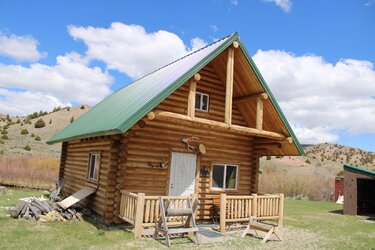
The perfect prepper cabin!
Now, in the posting we have the addresss: 6275 Lower Grasshopper. We need to head over to the GIS program for Montana. Every state should have its own GIS online, though some are better than others. There may be multiple! Some may not work! That's government work for yah. The best way to find them is to just search "state + GIS".
Now put in your address.
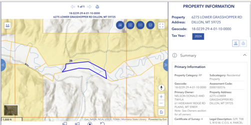
Boom, there's our property. The yellow it backs up to is government land, managed by the BLM. This is nice because it means the land is likely to stay undeveloped, and your land will continue to back up to woods. You can also see that there's a creek running through this property, and running water is VERY important to your long-term sustainability. Plus, fishing.
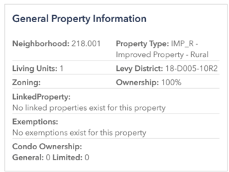
Scroll down on the right and you get to this box. "Zoning" being empty for Montana means that the land is unzoned. Now, we need to see what the agricultural laws are for unzoned land in Monata. The best place to start here, once again, is by searching for "(state) + livestock laws". If that doesn't work, go to the state's law webpage and start there. For Montana, that's leg.mt.gov. It may take some poking around to find exactly the law you're looking for, but it's a good plan to familiarize yourself with the laws of the state you'll be moving to. With Montana, TITLE 81. LIVESTOCK is our relevant section. There's nothing in that section about zoning or the amount of livestock you can keep on a property, so that means the state left it up to the municipal governments to decide.
First, figure out if your property is inside of a city. (if it is, that almost certainly means no livestock larger than chickens/rabbits in every state). For Montana, this is as simple as searching "Montana City Limits Map" and plugging your address into the result. This shows us that our parcel of land is far outside any city. In Montana, that means you're only subject to your county's laws.
To figure out which county government we're under, scroll down on the LandWatch page to the tax document and open it up. Alternatively, you can find a county map of the state and match it. Either way, we find that this property is in BEAVERHEAD COUNTY. The actual website for Beaverhead county isn't useful, but it has the files we need indexed on a search engine. Find them by searching "(county) + subdivision laws". We find the pdf here. Unfortunately, the pdf isn't terribly useful, and this is where the thread ends with "you're going to have to contact a human". The county website is at least useful for this, and has the commisioner phone numbers listed. If you're genuinely interested in that piece of land, calling one of them asking about laws is your best bet.
I've done this with a bunch of properties across several states and, unless you're buying an existing farm/homestead, this is usually how the hunt ends. If your property is inside city limits, you're likely going to be limited to hens & rabbits. If it isn't, and it isn't zoned residential nor zoned for ag, you'll have to contact a human to figure out if you can legally put cows on it.
Now, let's do that again for a property in Maryland.
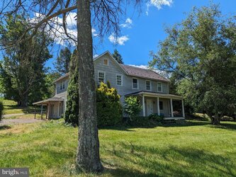
A crackshack in the making!
The address isn't listed but the coordinates are, so we can get the address as 2901 Conowingo Rd, Bel Air, MD 21015. We find Marlyand's land use GIS, and plug in our address.
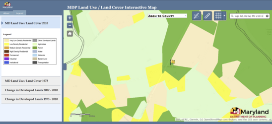
It's zoned "very low density residential", and any kind of "residential" zoning is usually bad news. Comparing it to the city limits map though, we can see it's outside the city. On that map, it's listed as being in HARFORD county. That also allows us to look the property up on Marlyand's property listing site. The use there is also listed as "residential". Here's the county website, and here's the zoning code.
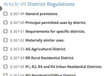 You'll notice that the zoning code talks about a bunch of different types of residential districts, where both the property listing and GIS merely use "residential". This is something I also run into frequently. We find our first useful definition:
Back to our definitions and:
You've been looking at LandWatch for a while and you've finally found that perfect piece of land. We will use this piece of property as our example.

The perfect prepper cabin!
Now, in the posting we have the addresss: 6275 Lower Grasshopper. We need to head over to the GIS program for Montana. Every state should have its own GIS online, though some are better than others. There may be multiple! Some may not work! That's government work for yah. The best way to find them is to just search "state + GIS".
Now put in your address.

Boom, there's our property. The yellow it backs up to is government land, managed by the BLM. This is nice because it means the land is likely to stay undeveloped, and your land will continue to back up to woods. You can also see that there's a creek running through this property, and running water is VERY important to your long-term sustainability. Plus, fishing.

Scroll down on the right and you get to this box. "Zoning" being empty for Montana means that the land is unzoned. Now, we need to see what the agricultural laws are for unzoned land in Monata. The best place to start here, once again, is by searching for "(state) + livestock laws". If that doesn't work, go to the state's law webpage and start there. For Montana, that's leg.mt.gov. It may take some poking around to find exactly the law you're looking for, but it's a good plan to familiarize yourself with the laws of the state you'll be moving to. With Montana, TITLE 81. LIVESTOCK is our relevant section. There's nothing in that section about zoning or the amount of livestock you can keep on a property, so that means the state left it up to the municipal governments to decide.
First, figure out if your property is inside of a city. (if it is, that almost certainly means no livestock larger than chickens/rabbits in every state). For Montana, this is as simple as searching "Montana City Limits Map" and plugging your address into the result. This shows us that our parcel of land is far outside any city. In Montana, that means you're only subject to your county's laws.
To figure out which county government we're under, scroll down on the LandWatch page to the tax document and open it up. Alternatively, you can find a county map of the state and match it. Either way, we find that this property is in BEAVERHEAD COUNTY. The actual website for Beaverhead county isn't useful, but it has the files we need indexed on a search engine. Find them by searching "(county) + subdivision laws". We find the pdf here. Unfortunately, the pdf isn't terribly useful, and this is where the thread ends with "you're going to have to contact a human". The county website is at least useful for this, and has the commisioner phone numbers listed. If you're genuinely interested in that piece of land, calling one of them asking about laws is your best bet.
I've done this with a bunch of properties across several states and, unless you're buying an existing farm/homestead, this is usually how the hunt ends. If your property is inside city limits, you're likely going to be limited to hens & rabbits. If it isn't, and it isn't zoned residential nor zoned for ag, you'll have to contact a human to figure out if you can legally put cows on it.
Now, let's do that again for a property in Maryland.

A crackshack in the making!
The address isn't listed but the coordinates are, so we can get the address as 2901 Conowingo Rd, Bel Air, MD 21015. We find Marlyand's land use GIS, and plug in our address.

It's zoned "very low density residential", and any kind of "residential" zoning is usually bad news. Comparing it to the city limits map though, we can see it's outside the city. On that map, it's listed as being in HARFORD county. That also allows us to look the property up on Marlyand's property listing site. The use there is also listed as "residential". Here's the county website, and here's the zoning code.
 You'll notice that the zoning code talks about a bunch of different types of residential districts, where both the property listing and GIS merely use "residential". This is something I also run into frequently. We find our first useful definition:
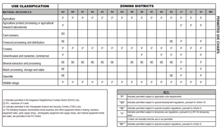
Which leads me to search the phrase "principal permitted use chart" and find this document. That document is your golden ticket-- if you can find one for your county, it's the most useful shorthand for figuring out if you can homestead on a piece of property. Dairy products, not allowed on any of the residential zoned properties. "Farm machinery and equipment (SIC-352)" also not allowed. "Offal or dead animal disposal or processing" also not allowed. However, confusingly, "Agriculture" is allowed:USE, RESIDENTIAL
Any dwelling unit or use listed on the Principal Permitted Use Charts, under the category of residential uses

Back to our definitions and:
Your best bet is to only buy property already zoned AG, not residential, rather than try to navigate murky laws around residential animal use.AGRICULTURE
All methods of production and management of livestock, crops, vegetation and soil. This includes the related activities of tillage, fertilization, pest control, harvesting and marketing. It also includes the activities of feeding, housing and maintaining of animals such as cattle, dairy cows, sheep, goats, hogs, horses and poultry and handling their by-products.