Hurricane Helene / Invest 97L

  • 🐕 I am attempting to get the site runnning as fast as possible. If you are experiencing slow page load times, please report it.

Cheese Balls

kiwifarms.net
Joined
Mar 22, 2024
Currently in the Atlantic, there is a tropical disturbance designated Invest 97L, likely to become Hurricane Helene in the coming days. Despite not even being formed yet, the model confidence is quite high that it will become a strong hurricane & impact the US on Thursday & Friday.
97L.png97L_tracks.png
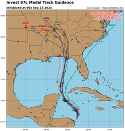
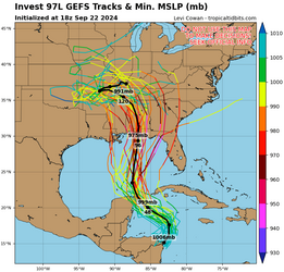
These are spaghetti plots of model forecasts for 97L/Helene - the models have really been targeting the Florida panhandle in recent runs, although I wouldn't be surprised if it shifts farther east towards the Big Bend of FL later on.
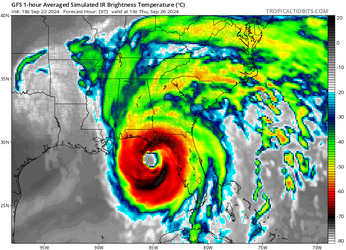
The biggest concern is possible rapid intensification starting near the Yucatan channel on Wednesday. The GFS has been particularly aggressive, showing a 945mb hurricane on the Florida coast by Thursday afternoon.
gfs-97L.png
Things can & will change, but so far, it doesn't look good for Florida.
Some relevant links:
Tropical Tidbits (great website for computer models)
National Hurricane Center (official government forecast site)
And to answer everyone's burning question: no, it will not impact The Notorious G.U.N.T in Merida.
 
It swinging right and hitting Tampa head on would be so funny. I know only one model predicted it but god the pandemonium that would break out between niggers that can't swim and the sheer amount of looting and lawlessness that would make DeSantis chimp out on national television....damn, it would be so kino.

The panhandle is boring (sorry Josh) so if the storms hits there it'll be business as usual. Predominantly white areas don't have looting issues which much of those cities are, and the minorities living there usually assimilate decently. Nothing too funny would come of it unless there's storm chaser beef.
Tampa is whiter/less black than the panhandle, especially the part Helene is predicted to hit. Most of the panhandle is not Pensacola. It is boring though, looting not likely. And literally who gives a fuck about Tampa I think people care about it about the same as the panhandle.
 
Panic is setting in on the weather models. This is going to be a big one. West coast Florida bros should probably start packing.

This is a wild track too. This bitch formed from a pressure wave across Central America from the Pacific and is now going to thread the Yucatan Straights before turning northeast to Florida? That is fucking unheard of.
 
Last edited:
Panic is setting in on the weather models. This is going to be a big one. West coast Florida bros should probably start packing.

This is a wild track too. This bitch formed from a pressure wave across Central America from the Pacific and is now going to thread the Yucatan Straights before turning northeast to Florida? That is fucking unheard of.
Only time something crazy like that happened iirc was Francis doing a whole ass U-Turn
 
Interested observer knowing nothing of hurricane formation. Please expand?
Most Hurricans form by coming across the Atlantic along the trade winds. Which means that in order to plow into the USA they usually get shredded by the barrier Islands of the Antilles and Cuba before entering the gulf, or else turning North and slowing down over the cooler waters of the North Atlantic before hitting the east coast.

This storm formed behind the barrier islands and has taken the ONLY possible course to strengthen by threading the needle between Cuba and Mexico. Before turning North East and hitting west Florida. Which also rarely happens. Most Florida strikes are on the South and East coasts.
If I understand what you're saying correctly, there's been a couple that have taken this path. Both have been pretty major hurricanes, due to what you said. Michael was a cat 5 and demolished a large stretch of the panhandle. Huge tracts of forest were flattened. Idalia was a cat 4, the aftermath caused major industries to move out of the area. This history is what's gotten the state into a panic. I know disaster agencies and response teams have been working overtime to prepare since Saturday at least.

A couple panhandle counties are under mandatory Evac for everyone in the entire county. I think most other counties along the gulf coast are on varying Evac orders for special needs and more dangerous zones. Looks like basically the entire state is going to get hit. It's going to be an interesting one for sure.
 
If the current runs from the hurricane model suite verify, the Governor is likely to be spending his weekend fixing the roof. Helene will be moving too quickly at landfall for rapid weakening (the current official forecast has her still at hurricane strength over southern Georgia just after midnight on Friday morning), and if she comes in slightly west of Tallahassee she could still bring category 2\category 3 strength gusts to the city even that far inland, which would be pretty much unprecedented.
 
Carolinas put under flood warning just now. They are forecasting 15 inches of rain to fall on the Blue Ridge Mountains in western North Carolina. Which is not good, especially considering how wet it's already been this month.
 
Why? They aren't even in the cone of uncertainty

Not doxing myself but I'm south-east of Tampa, more inland, and I'm not even putting up storm shutters for this. Unless that thing just hauls right just before it gets to Tampa and if that happens, well, I won't be posting for a while...which some folks may think is good!
 
Back