- Joined
- Aug 25, 2017
I posted one a couple months ago. It's very low res, but I couldn't find anyone that lets you see usable resolution for free anymore. They all wised up. I wouldn't count on Google, Bing or ArcGIS updating any time soon with something better.I can't wait until new sat photo's are taken of the area. The destruction will be clearly visible from space. Its green everywhere but the tranch.
The neighbors have cows but clearly they know how to manage their land.
Now I can appreciate the devastation on the ground even more after seeing the most recent shots from the fence line.I went looking earlier in the thread. Neither google or bing have recent sat images. There used be a fair few imaging companies that had some kind of online free trial. There was always restrictions, but you could get stuff much more recent than google or bing with decent resolution. Seems like they all wised up. I did just find one that offers shit resolution, but its enough to see what they've done.
Their troonery is visible from space.
View attachment 2088206
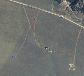
Just look at the difference in vegetation between their lot and their neighbors' lots.
An interesting thing I didn't comment on before is that the driveway with their westerly neighbor used to connect to theirs. The top two look like ATV trails, while the the bottom one is clearly a wider dirt track for vehicles. Looking back through the parcel owner history it shows the two lots were owned by the same family at two different points and there were small sheds built on the western property during one of those periods. I was wondering if the two neighbors just happened to be good friends who let each other borrow trailers or other heavy equipment, but it seems not.


